
Fájl:Reliefkarte Frankreich.png

Az előnézet mérete: 618 × 599 képpont További felbontások: 247 × 240 képpont | 495 × 480 képpont | 792 × 768 képpont | 1 056 × 1 024 képpont | 2 112 × 2 048 képpont | 2 958 × 2 869 képpont.
Eredeti fájl (2 958 × 2 869 képpont, fájlméret: 10,28 MB, MIME-típus: image/png)
Összefoglaló
| Leírás |
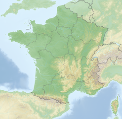
Deutsch: Reliefkarte Frankreich
Topographischer Hintergrund: NASA Shuttle Radar Topography Mission (public domain). SRTM3 v.2. |
||||||||
| Dátum | |||||||||
| Forrás | A feltöltő saját munkája | ||||||||
| Szerző | Tschubby | ||||||||
| Engedély (Fájl újrafelhasználása) |
Én, e mű szerzője a művemet az alábbi licencek alatt teszem közzé:
Ez a fájl a Creative Commons Nevezd meg! – Így add tovább! 2.5 Általános, 2.0 Általános és 1.0 Általános licencek alapján használható fel.
A mű a fenti licencek bármelyike szerint felhasználható. |

Fájltörténet
Kattints egy időpontra, hogy a fájl akkori állapotát láthasd.
| Dátum/idő | Bélyegkép | Felbontás | Feltöltő | Megjegyzés | |
|---|---|---|---|---|---|
| aktuális | 2018. május 18., 11:50 | | 2 958 × 2 869 (10,28 MB) | Tschubby | {{Information |description= |source= |date= |author= |permission= |other versions= }} |
| 2018. május 18., 11:23 |  | 2 958 × 2 869 (10,28 MB) | Tschubby | == {{int:filedesc}} == {{Information |Description= {{de| Reliefkarte Frankreich}} Topographischer Hintergrund: [http://www2.jpl.nasa.gov/srtm NASA Shuttle Radar Topography Mission] (public domain). SRTM3 v.2.<br /> Grenzverläufe: File:France location map-Regions-2016.svg |Source={{own}} |Date= 2018-05-18 |Author= Tschubby |Permission= {{self|GFDL|Cc-by-sa-3.0-migrated|Cc-by-sa-2.5,2.0,1.0}} |other_versions= }} Category:Topographic maps of France |
Fájlhasználat
Az alábbi lapok használják ezt a fájlt:
Globális fájlhasználat
A következő wikik használják ezt a fájlt:
- Használata itt: de.wikipedia.org
- Eiffelturm
- Frankreich
- Transall C-160
- Freising
- Île du Levant
- Villebon-sur-Yvette
- Volvic (Mineralwasser)
- Cevennen
- Cotentin
- Längstwellensender HWU
- Lac de Serre-Ponçon
- Wittschlössel
- Lac du Der-Chantecoq
- Île de Noirmoutier
- Aiguille du Midi
- Dentelles de Montmirail
- Fort Boyard
- Sendeturm Mulhouse-Belvédère
- Golf von Morbihan
- Porquerolles
- Massif des Maures
- Cézallier
- Tignes-Talsperre
- Vorlage:Positionskarte
- Grand-Maison
- Lac de Vouglans
- Vorlage:Positionskarte Frankreich
- Benutzer:Spischot/Spielwiese
- Vorlage:Infobox Pass/Test
- Nekropole von Bougon
- Île d’Or
- Iroise
- Luz Ardiden
- Sender Lafayette
- Vorlage:Positionskarte Frankreich Korsika
- Vorlage:Positionskarte/Doku
- Cap Leucate
- Burg Poissy
- Burg Salignac
- Burg Blandy-les-Tours
- Kategorie:Rennstrecke in Frankreich
- Burg Puilaurens
- Wikipedia:Kartenwerkstatt/Positionskarten/Europa
- Chaîne des Puys
- Vorlage:Positionskarte Frankreich Finistère
- Vorlage:Positionskarte Frankreich Bretagne
- Burg Roquebrune-Cap-Martin
- Vorlage:Positionskarte Frankreich Poitou-Charentes
- Vorlage:Positionskarte Frankreich Loire-Atlantique
- Vorlage:Positionskarte Frankreich Morbihan
A fájl globális használatának megtekintése